Cherrapunji (Sohra) Travel Guide 2026: Best Places to Visit, Stays & Tips
Cherrapunjee/Cherrapunji, also known as Sohra, is a high-altitude town in the Northeast Indian state of Meghalaya. It is a captivating travel destination renowned for its stunning natural beauty and unique experiences including living root bridges, stunning caves and cascading waterfalls. As one of the wettest places on Earth, Cherrapunji receives an average annual rainfall of over 11,000 mm, resulting in vibrant greenery and cascading waterfalls that create a picturesque setting. You can read more about the waterfalls in the blog “Ten must visit Waterfalls in Meghalaya” The region's unique topography, often shrouded in mist, enhances its ethereal charm, making it a paradise for nature lovers. The locals of Cherrapunji are predominantly Khasi people, and their unique culture is worth exploring. Visitors can also try the local delicacies like Jadoh, a rice-based dish, and the famous betel nut, which is chewed by the locals.
Cherrapunji beckons with its myriad attractions, from cascading waterfalls and lush forests to quaint villages steeped in history and culture. Guests have the opportunity to embark on guided tours and excursions, exploring the wonders of this enchanting region with the assistance of knowledgeable local guides. Whether trekking through the verdant valleys, immersing oneself in the vibrant street markets, or simply communing with nature in solitude, Cherrapunjee offers endless possibilities for adventure and discovery.
Cherrapunji to Shillong distance is about 54 kms and it takes about 2 hours due to the traffic from Shillong. If you are looking for an Offbeat Adventure in Meghalaya, Cherrapunjee is definitely the right place for you.
Cherrapunji Travel Trips
Here are some of the must-visit places in Cherrapunjee:
Nohkalikai Falls: This majestic waterfall plunges a whopping 1,100 feet, making it the tallest plunge waterfall in India. Witness the cascading waters surrounded by lush greenery and enjoy the breathtaking views from the observation deck.
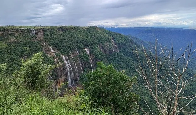
Seven Sisters Falls: This captivating series of seven waterfalls cascading down a rocky cliff face is a sight to behold. Enjoy the scenic beauty and the refreshing atmosphere amidst the lush surroundings.
Mawsynram Village: While not technically in Cherrapunjee, Mawsynram, located just 15 km away, holds the distinction of being the wettest place on Earth. Experience the unique charm of the village and witness the dramatic waterfalls during the monsoon season.
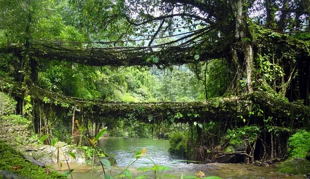
Double Decker Living Root Bridge: The Double Decker Living Root Bridge is a remarkable natural structure located in Nongriat, near Cherrapunji (Sohra). The bridge is constructed using the roots of rubber trees, which are trained to grow across streams using bamboo scaffolding. This process can take 20 to 30 years for the roots to mature and become self-supporting. The bridge is approximately 175 feet long, with its height providing scenic views of the surrounding rainforest
Mawkdok Dympep Valley Viewpoint: Take in the panoramic vistas of the East Khasi Hills from the Mawkdok Dympep Valley Viewpoint. Enjoy the breathtaking views, especially during sunrise or sunset.
Mawsmai Cave: Mawsmai Cave, located near Cherrapunji in Meghalaya, India, is one of the most renowned limestone caves in the region. The cave is primarily composed of limestone, shaped over centuries by natural erosion and the flow of underground water. This has resulted in unique formations such as stalactites and stalagmites, which are visible throughout the cave. Although the cave extends beyond the tourist-accessible area, only about 150 meters is open to visitors. Inside, the cave features both spacious halls resembling amphitheaters and narrow passages that require bending or crawling to navigate
Krem Phyllut: For the more adventurous souls, Krem Phyllut offers a challenging yet rewarding caving experience. Crawl through narrow passages, discover hidden chambers, and witness the fascinating underground world.
Thangkharang Park: This scenic park boasts a man-made lake surrounded by lush greenery. Enjoy boating on the lake, explore the nearby caves, or simply relax amidst the tranquil surroundings.
Eco Park: Spread over 70 acres, the Eco Park offers a variety of activities for visitors of all ages. Enjoy boating on the lake, explore the orchid enclosure, or spot some of the park's resident birds.
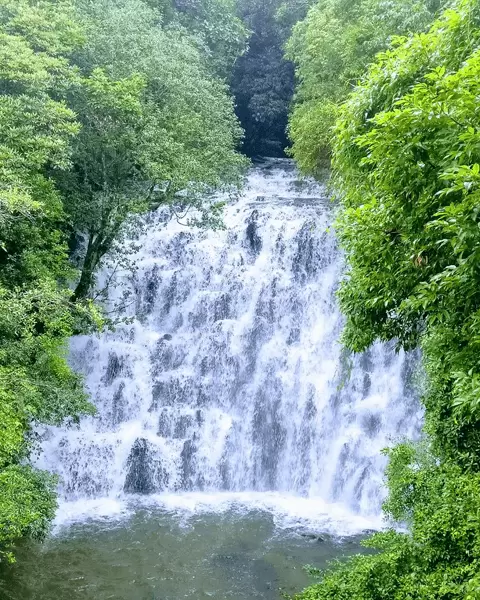
Wei Sawdong Falls: Wei Sawdong Falls is a stunning three-tiered waterfall located against the forest canopy in Cherrapunji. The falls are situated in the East Khasi Hills district, near Dainthlen Falls. Accessing Wei Sawdong Falls involves a challenging trek along an out-and-back trail, which is steep and can be muddy, especially after rain. The trek typically takes about 20 minutes and includes navigating bamboo ladders and rocky paths. It is advisable to borrow a bamboo stick which is available at the entrance- it will be of great use when climbing back up.
Cherrapunjee doesn't have enough good hotel and resorts to keep up with the ever increasing demand. Lot of people from Guwahati drive down to Cherrapunjee on weekends and long holidays making it even more difficult to get rooms almost all year round. Therefore, if you are tourist from outside the state, it is imperative that you book your Stays in Cherrapunjee much before in advance. Below are some of the good hotels, resorts in Cherrapunjee which won't burn a hole in your pocket and still offer really good service:
If you wish to read more, you can check the 10 best resorts in Cherrapunji blog to know more about your stay options in Cherrapunji.
Why is Cherrapunji also known as Sohra?
Cherrapunji, known locally as Sohra, derives its name from the Khasi language and has historical significance tied to the region's indigenous culture. The name "Sohra" is believed to mean "the land of oranges," which reflects the area's agricultural heritage. The British colonial administration, unable to pronounce "Sohra," adapted it to "Cherra," which later evolved into "Cherrapunji"—a name that included "punji," a Bengali term for a cluster of villages. Historically, Sohra served as the capital of the Khasi tribal kingdom, known as ka himaSohra, and has been a center of Khasi culture and literature. The local population has long referred to the town as Sohra, and recent efforts have been made to officially revert to this original name, reflecting a desire to honor local heritage and traditions. The Meghalaya government has initiated this name change, which has been welcomed by local historians and cultural advocates. Thus, the dual naming of Cherrapunji/Sohra highlights both colonial influence and the importance of indigenous identity in the region.
Best time to visit Cherrapunji:
October to February is generally regarded as the best time to visit Cherrapunji for comfortable weather and fewer rain-related disruptions. The monsoons will be receding during that time but the waterfalls will still be gushing and the surrounding lush greenery will not have subsided signficantly. You can further read our blog Best time to visit Meghalaya to know more about the best months to visit
Is Cherrapunji Really the Wettest Place on Earth?
This needs to be handled carefully on the new page.
Cherrapunji/Sohra is one of the wettest places on Earth, but it is not accurate to simply state that it is currently the wettest place on Earth.
Mawsynram, also in Meghalaya, is generally recognised as receiving higher average annual rainfall.
Sohra nevertheless holds remarkable historical rainfall records and remains one of the world's most famous high-rainfall locations.
Few things you need to keep in mind when travelling to Cherrapunji:
Respect the local culture , don't forget to carry good footwear for walks and treks. Slippers and swim wear for jumping into water bodies and towels and extra pair of clothes.
Rain coat, umbrella is recommended due to heavy rains in most months
It is best to get a taxi with a local driver as it can get very foggy at night and self driving at night is not recommended in Meghalaya
There are not many good resorts and homestays in Cherrapunji and there is excess demand. Therefore it is important that you book your stay in advance (you can reach out to us for this) when you are travelling to Cherrapunjee
Cherrapunji Travel Tips
Because Sohra receives heavy rainfall, travellers should prepare appropriately.
Carry proper footwear
For caves and trekking, grippy walking shoes are much more useful than slippers.
Carry rain protection
Even outside peak monsoon, showers can occur unexpectedly.
Don't underestimate the treks
The Nongriat trek is physically demanding because of the large number of steps. Meghalaya Tourism recommends suitable footwear and preparation for the terrain.
Don't rush the waterfalls
Visibility and water flow can change quickly with weather.
Hire local guides where appropriate
A local guide is particularly useful for longer treks, caves and village experiences.
Book accommodation in advance
Sohra can become particularly busy during holidays and peak travel periods. Meghalaya Tourism itself advises advance accommodation booking during busy periods.
Cherrapunji FAQs
Is Cherrapunji and Sohra the same place?
Yes. Sohra is the local name for the destination commonly known as Cherrapunji or Cherrapunjee. The Meghalaya Government uses Sohra (Cherrapunjee) in its tourism information.
Which waterfalls should I visit in Cherrapunji?
The major ones include Nohkalikai, Seven Sisters, Dainthlen and Wei Sawdong, while Rainbow Falls can be included as part of the Nongriat trek.
Why is Cherrapunji famous?
Cherrapunji is famous for its extraordinary rainfall, spectacular waterfalls, limestone caves, living root bridges and Khasi culture.
Is Cherrapunji worth visiting?
Yes. Sohra offers a combination of waterfalls, caves, trekking, living root bridges, forests and Khasi culture that makes it one of Meghalaya's most diverse destinations.
How far is Cherrapunji from Shillong?
Sohra is approximately 53 km from Shillong by road.
What is the best time to visit Cherrapunji?
October to March is generally good for trekking and sightseeing. The monsoon months from June to September are best if you specifically want to see the waterfalls at their most dramatic, but rain can make trekking and road travel more challenging.
Can I see the Double Decker Living Root Bridge in one day?
Yes, it is possible as a demanding day trek from Sohra/Tyrna, but you need to start early and be reasonably fit. The route involves roughly 3,000–3,500 steps.
How far is the Double Decker Living Root Bridge from Cherrapunji?
Nongriat is approximately 15 km from Sohra by road, with the trek beginning at Tyrna.
Is Cherrapunji good for families?
Yes, especially for waterfalls, viewpoints, caves and nature experiences. However, some activities such as the Nongriat trek are strenuous and aren't suitable for everyone.
Can I visit Cherrapunji during the monsoon?
Absolutely. In fact, the monsoon is when Sohra's landscape is at its most dramatic. However, heavy rain can make trails slippery and may occasionally disrupt roads.
How many days are enough for Cherrapunji?
2–3 nights is a good starting point. If you want to trek to Nongriat, explore caves and experience local villages without rushing, 3–4 nights is better.
For a customized Meghalaya tour experience you can contact us at +91-7669503993 or email to contact@ourguest.in
Cherrapunji Facts
Cherrapunjee is most popular due to the area receiving the highest rainfall in the world and therefore known as the wettest place on the earth. Over time, Cherrapunji is having a significant decrease trend in rainfall & Mawsynram on the other hand is experiencing increase in its rainfall pattern & now Mawsynram receives the highest rainfall in India.The average annual rainfall in Cherrapunjee is 11,872 millimetres. It held the record for the most rainfall in a single year (1,042 inches or 26,467 mm) from August 1860 to July 1861, and the highest one-month total (366 inches or 9,296 mm) in July 1861. The town is situated high atop the Shillong plateau, in the East Khasi hills. This plateau averages about 1,480 m above sea level and lies as much as 1,000 m above the floors of the surrounding valleys. The town itself sits at an altitude of 1,260 m above sea level.
How to Reach
By Air
To get to Cherrapunji town, you can hire taxis from Paltan Bazaar bus stand in Guwahati or get a pre-paid taxi from the airport itself. Technically, the Umroi Airport (91 km) near Shillong is the nearest airport to Cherrapunji.
By Train
Guwahati acts as the nearest railhead to Cherrapunji. Although it lies at a distance of 181 km from this region, bus serviceor taxis can be availed from the railway station. Guwahati railway station is well connected to the entire country and regular trains carry passengers to and fro.
By Road
Buses for Cherrapunji leave from the Sohra Bus Stand in the Bara Bazaar area of Shillong.