Understanding Arunachal Pradesh Inner Line Permit System
Nov 29th, 2023
Log in to your Account
Share![]()
Meghalaya, the "Abode of Clouds", is often celebrated for Shillong, Cherrapunji, and Dawki. But beyond these popular spots lie hidden villages, mystical caves, and untouched valleys that remain off the beaten path. If you're a curious traveler seeking raw landscapes, vibrant tribal cultures, and tranquil getaways, this curated list of offbeat destinations in Meghalaya promises authentic and unforgettable experiences.
Location: Amlarem Block, Jaintia Hills (36 km from Jowai)
Access: 2-hour trek from Shnongpdeng or longer trek from Amkoi side
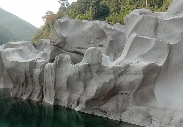
This is a remote village located in the Amlarem Block of the Jantia Hills about 36 kms from Jowai, that requires a 2 hour trek from Shnongpdeng. There are about 800 people that reside there and speak the Amkoi language. This place is known for its unique white rock formations caused as a result of centuries of weathering and erosion by the meandering Umngot River. The rocks there do not have the usual craggy look and have been naturally smoothened. They look like they have been painted with different faded colours. The most popular spot for cliff jumping into the turquoise river below is the Sliang tourist spot. There are two ways one can reach this place - the long and difficult one from Amkoi or the relatively short and easy one from Shnongpdeng. This place has caught the eye of many explorers but is still less crowded.
Location: East Khasi Hills, en route to Dawki
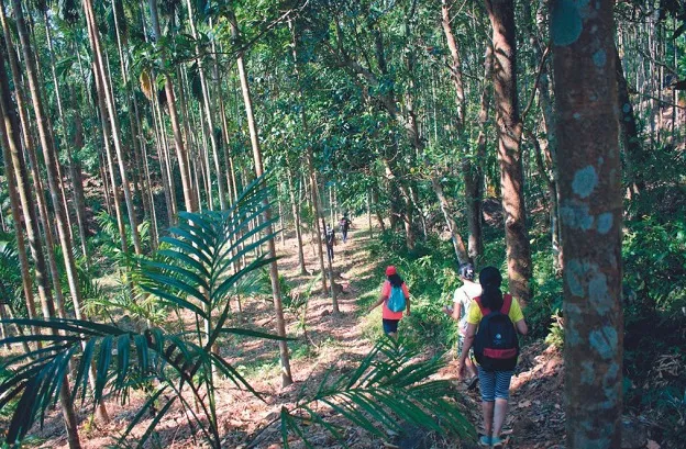
Visitors to Meghalaya often overlook the Pynursla region which is home to multiple root bridges, which can be accessed via short comfortable hikes.
The charming pine-dotted countryside at Langkawet is known for its small lakes. Wah Rymben Falls has few visitors so it can be an offbeat addition to your list – it involves a short descent from Lapalang village. Pynursla region is famous for its fruits and jungle produce. Make sure you grab a bag of the famous oranges here if you happen to visit in winter.
Location: Wahkhen Village, East Khasi Hills
Trek Season: October–April (dry & safe trail conditions)
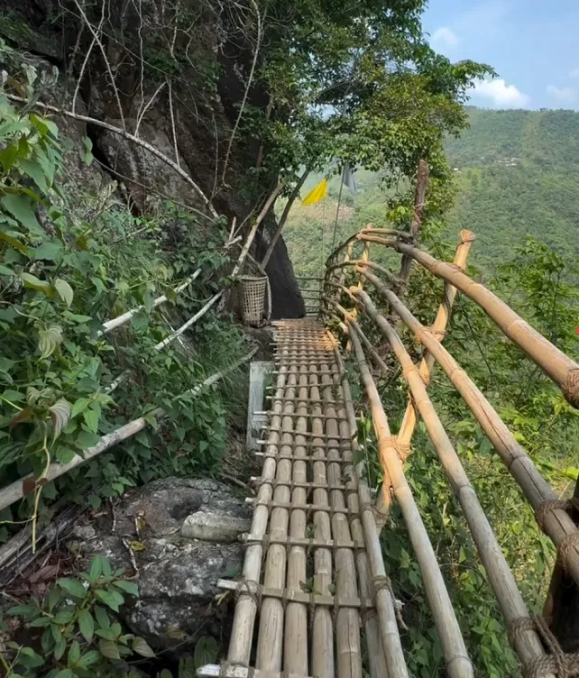
The Mawryngkhang Trek which is also known as the Bamboo Trail in Wahkhen Village, is one of the most thrilling and scenic treks in Northeast India. The trek revolves around the folklore of U Mawryngkhang ("King of Stones"), who battled another rock, Mawpator, for love. The scars of their battle are said to be still visible on the rocks
The trail includes around 50+ bamboo bridges built by local villagers, many of which hang over deep gorges. The most thrilling section is the Mawkhleing Cliff skywalk, where the bridge has no support below—only vertical bamboo poles anchoring it to the cliff. Best time for the trek is from October–April as you will be avoiding the peak rainy season. It is the ideal time to do this trek as the trail is non-slippery and safer. The trek is not recommended for those with acrophobia or fear of heights. This is an offbeat experience with less crowds that combines adventure, folklore, and stunning landscapes—perfect for thrill-seekers and nature lovers.
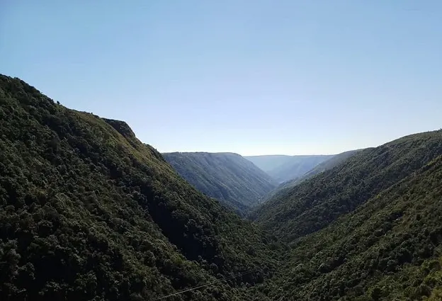
Location: On Shillong–Cherrapunji highway
Distance: 24 km from Cherrapunji, 30 km from Shillong
Best Time: October–May (clear skies); June–September (misty ambiance)
Located on the Shillong-Cherrapunji highway, around 24 kms from Cherrapunji and and 30 kms from Shillong, Dympep Valley offers panoramic views of a V-shaped gorge flanked by lush green hill. The ideal months to visit are October–May for clear skies; June–September for misty, monsoon charm,though visibility may be limited. The best time of day is early morning or late afternoon for optimal lighting and fewer crowds.
You can combine this visit with the Seven Sisters Falls, Mawsmai Cave, or Nohkalikai Falls nearby. The valley remains untouched by commercialization, offering a serene escape.
Region: Sub-division in West Jaintia Hills, about 90 km from Shillong and 36 km from Jowai.
Amlarem region is dotted with pristine waterfalls, living root bridges, crystal-clear rivers, and limestone caves. The best time to visit is October–May which is an ideal time for trekking, caving, and clear river views. During June–September the region is lush with monsoon landscapes but slippery trails.
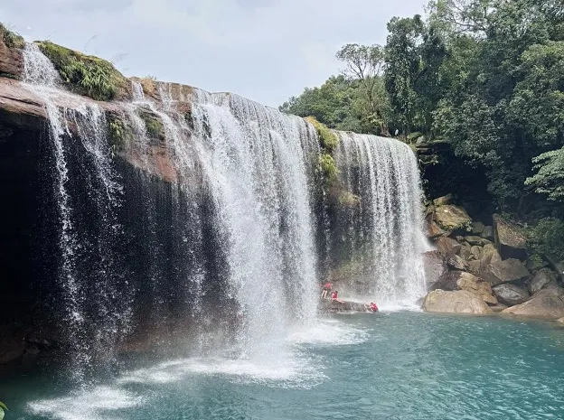
Arguably one of the most beautiful waterfalls in Meghalaya, this turquoise colored falls cascading over a cave, surrounded by dense forests is located about 30 kms from Jowai.
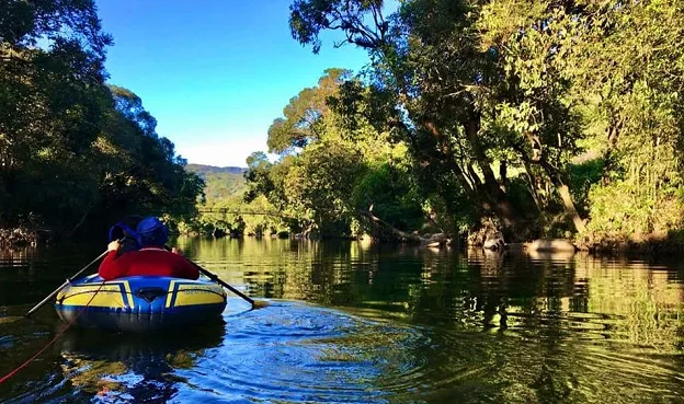
Located a little upriver from Dawki, Shnongpdeng is the adventure hub on the Umngot River which is famous for its glass-clear waters.Visitors can indulge in adventure activities like zip-lining, scuba diving, snorkeling, and river camping etc.
Kudengrim is a picturesque village nestled in the West Jaintia Hills, known for its untouched natural beauty. It is well known for its Living Root Bridges. The Kudengrim Living Root Bridge, a two-tiered marvel woven from Ficus Elastica roots, is the village’s crown jewel. A short hike through dense forests leads to this architectural wonder.The Padu and Nongbareh root bridges offer additional scenic spots, with crystal-clear lakes and swimming opportunities.
A trio of waterfalls awaits explorers like the Segmented Waterfall. A 20-minute hike from the village reveals a broad, cinematic cascade. Mukhre Step Falls that can be accessed via bamboo paths and stream crossings.this curtain-like waterfall completes the trio. The Bamboo Skywalk & Canopy Hut offers panoramic views of the waterfalls and valleys. Tree House is a picturesque spot overlooking a lake, perfect for relaxation and photography. St. Peter’s Bamboo Church is a unique architectural feat whose structure is made entirely of bamboo. A 20-minute hike from the village leads to the living root bridges and waterfall.You can get views of verdant valleys and bamboo skywalks from here.
It is a network of 11 limestone caves - Amsohmahatang, Kriah with historical significance. Known for its impressive stalactite and stalagmite formations. These caves are renowned for their stunning geological features, formed over thousands of years through the slow deposition of minerals from dripping water. The intricate patterns and formations within the caves offer a glimpse into the geological processes that have shaped the region
Phe Phe falls is a stunning two-tiered waterfall located in Shkentalang Village, West Jaintia Hills, Meghalaya. Known for its turquoise-blue pool and lush surroundings, it’s often called "Paradise Falls” translated from the Jaintia word "Phe Phe". It is a relatively unexplored spot, offering a serene escape from crowds. The waterfall cascades from a height of 300 feet into a crystal-clear pool, surrounded by bamboo forests and pitcher plants. The upper tier is accessible via a short trek, offering panoramic views.
Rupasor Bathing Ghat, also known as Ka Mahadei Swimming Pool, is a historic rectangular pool carved out of granite in Syndai Village. It was built during the Jaintia Kingdom about 500 years ago and served as a royal bathing site for kings and their families. The ghat features intricate rock carvings, including an elephant replica and symbols of the sun and moon, reflecting ancient craftsmanship and cultural significance.
The bathing ghat is 19.5 ft long, 15 ft wide, and 5 ft deep, fed by the Rupasor stream. The water channel resembles an elephant’s trunk and features the sun and moon carvings on nearby rocks, symbolizing fertility in the Khasi-Jaintia traditions. It was used by kings en route between their capitals from Jaintiapur in Bangladesh and Nartiang which was the summer capital.
Nongbareh Rim is a picturesque village nestled in the Amlarem Subdivision of West Jaintia Hills, Meghalaya. Known for its lush greenery, ancient living root bridges and serene river valleys, it’s an emerging offbeat destination for adventure seekers and nature lovers.
Some of the key attractions here include :
Nongbareh Root Bridge: A 400-year-old double-span bridge in the village center, crossing the Amayalee River. Its intricate aerial roots and bamboo railings make it a marvel of bioengineering.
Rbang U Thlah Bridge: A steeply accessed bridge near Shmia Syntem, used daily by villagers.
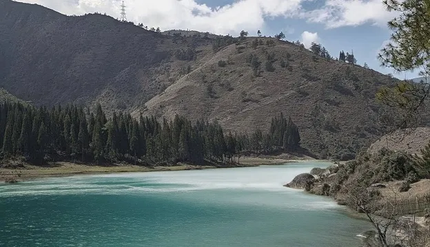
Shmia Syntem River Valley: A stunning valley along the Umngot River, featuring emerald-green waters, white boulders, and a bamboo bridge. The descent takes about 1 hour, with ancestral stone pathways and bamboo water pipelines.
Community Fish Sanctuary: Home to the endangered chocolate mahseer fish. Locals believe consuming these fish, can cure illnesses. You can also explore Wah Lymbui (upriver) and Nangthlu (downriver), both offering pristine landscapes.
The Thlumuwi Stone Bridge is a remarkable ancient structure located near Chkentalang Village, on the Jowai-Amlarem Road.Built over the Muwi Stream, this bridge was constructed under the orders of the Jaintia Kings by artisans U Mar Phalyngki and U Luh Lamare to facilitate royal travel between the kingdom’s summer capital, Nartiang and winter capital Jaintiapur. The bridge consists of huge granite slabs perched on stone pillars, spanning 26.5 meters in length. Its simple yet robust design showcases the engineering prowess of the Jaintia Kingdom. The remnants of dolmens and menhirs (resting stones for travelers) can be found, though some are now overgrown. Part of the "Ka Luti Syiem" or Royal Path, a 70 km stone-paved route connecting Nartiang to Jaintiapur. This path included four megalithic bridges, with Thlumuwi being the most accessible. Local folklore attributes its construction to legendary giants U Luh Laskor and U Mar Phalangki from Nartiang.
The bridge’s name, "Thlumuwi", derives from the Muwi Stream it crosses. "Thlu" means stone, and "Muwi" refers to the river. Nearby attractions include the Muwi Waterfalls and sections of the royal path with Kor Shongthait (resting stones). The Thlumuwi Bridge offers a rare glimpse into ancient Khasi-Jaintia engineering and royal history. Its combination of mythology, architecture, and scenic surroundings makes it a must-visit for history buffs and offbeat travelers
Location: Mawsynram Subdivision, East Khasi Hills
Claim to Fame: 11,872 mm average rainfall annually
Langsymphut village is located in the Mawsynram subdivision of East Khasi Hills district and is renowned as the wettest place on Earth, with an average annual rainfall of 11,872 mm. Locals use "knups" or full-body umbrellas made of bamboo and banana leaves, to withstand heavy rains. The houses are soundproofed to muffle the deafening sound of rain. Nearby tourist attractions include Nohkalikai Falls that has India’s tallest plunge waterfall (340 meters). Living Root Bridges that are engineered from rubber tree roots, durable against heavy rains. Khreng Khreng Viewpoint that offers panoramic views of the misty Khasi Hills. October–November (post-monsoon) is the best time to travel for clearer skies.
Location: East Khasi Hills
Nongjrong Village is a hidden gem in Meghalaya’s East Khasi Hills, celebrated for its surreal landscapes, English-speaking community, and untouched natural beauty.
One of the village’s unique features is that it is one of India’s rare villages where English is the primary language spoken by its 1,440 residents. Places to visit nearby include:
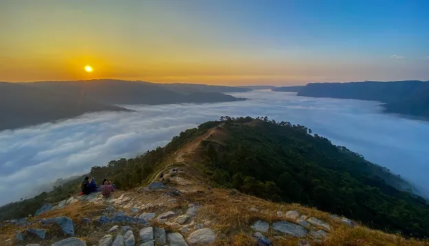
Nongjrong Viewpoint: A hilltop vantage point accessible via a short trek, famous for its sunrise spectacle where clouds blanket the valley like a "white sea". It is best visited before dawn (arrive by 4 AM) for golden hues piercing through mist.
Nongjrong Waterfalls: A 3 km trek through dense forests leads to this cascading waterfall, especially vibrant during monsoons.
Location: Nartiang Village, West Jaintia Hills (26 km from Jowai)
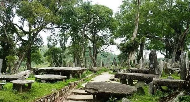
Somewhat similar to The Stonehenge in England,the Nartiang Monoliths are one of Meghalaya’s most fascinating historical and cultural sites. Located in Nartiang village, West Jaintia Hills around 26 km from Jowai and 62 km from Shillong, it has the largest collection of megalithic structures in a single area, dating back to 1500–1835 CE, erected by Jaintia kings and clans. The stones represent a blend of matrilineal tribal heritage, Hindu influences, and colonial history. The site was once the summer capital of the Jaintiapur Kingdom; a matrilineal realm spanning present-day Meghalaya and Bangladesh.The stones served as memorials, market stalls, and political gathering sites
According to legends & folklore, a myth tells of a giant, Mar Phalyngki, carrying a stone slab as an umbrella, leading to the market’s relocation. It is said that human sacrifice was also initiated and that the tallest menhir allegedly required a sacrifice to stand upright.
Nearby Attractions include the Nartiang Durga Temple. A 500-year-old Shakti Peetha with a dark history of human sacrifices that is now replaced by animal offerings.
Location: South Garo Hills, along the Simsang River
Siju is a small village located on the road halfway between Nongalbibra and Baghmara, the District Headquarter of South Garo Hills, along the Simsang River.
Siju is well known for its huge limestone bat cave or Dobakkol which is considered one of the longest cave systems in Asia. Siju cave is 5 km away from Duramong Siju bazaar on the main road but it is motorable right up to 50 meters from the mouth of the cave.
It is a Bat Haven and hosts thousands of bats, including the rare Hipposideros larvatus, and unique cave-dwelling species like blind fish and shrimp.Siju caves are also considered a geological marvel of stalactites, stalagmites, and the "Princess Di’s Chamber"—a stunning limestone gallery. Guided tours cover 2–3 hours of knee-deep wading and spelunking trips delve deeper into the cravass. The Siju Wildlife Sanctuary is known for its biodiversity where one can spot elephants, hoolock gibbons, and rare birds like the peacock pheasant and Siberian duck. The trekking trails lead to Goera Ronggat, known for its limestone formations resembling the Angkor Wat ruins.
The Simsang River & Dabat Wari is a serene spot 150m from the cave entrance, ideal for kayaking or picnics. There are also millions-year-old marine fossil beds of shells and starfish scattered across the village, offering a glimpse into prehistoric life. The best time to visit is from October–April and avoid the monsoon months due to flooding.
One can learn about the Garo culture and tribal traditions and folklore tied to the caves besides studying the unique ecosystems and ancient fossils.
There are also many fish sanctuaries nearby that one can visit like the Jadiasil, Aginma Wari, Jadi Gindam Sanctuaries etc.
Location: Mylliem, East Khasi Hills (25 km from Shillong)
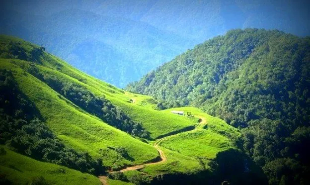
Nestled in Mylliem, East Khasi Hills about 25 km from Shillong, this place gained attention in 2021 after being popularized by the Meghalaya Cycling Association.Its unique appeal lies in its serene convergence of meadows, pine forests, and rivers, often compared to Kashmir.
There is a moderate trek through rocky paths and dense forests about 30–45 minutes downhill covering about 1.5 km.
The landscape is scenic where a vast meadow meets two flanked by towering pine trees and rainforest-covered hills.
Visitors can indulge in boating, camping and trekking.The best time to visit is from October–March. This spot offers offbeat tranquility and escape from the crowds with minimal tourist footfall. You can combine your trip with the nearby Elephant Falls for a day trip.
October to May: Ideal for trekking, waterfalls, and scenic views
Avoid July & August: Peak monsoon makes trails slippery and access tough
If you wish to know more about when to travel to Meghalaya, you can check our blog Best time to visit Meghalaya.
Prerna, a seasoned travel & hospitality expert, isn't just a writer – she's a curator of experiences. Leading OurGuest's operations at The Barfung Retreat, she leverages her extensive background at Taj, Hyatt, ITC, and more. A Master's graduate in English Literature, Prerna's passion for storytelling is fueled by her childhood spent traversing India with her police officer father. Fluent in Bengali, Hindi, English, and Nepali, she fosters genuine connections across cultures. Join Prerna as she unveils the hidden gems and vibrant soul of Northeast India, one captivating story at a time.
For a customized Offbeat Meghalaya tour experience you can contact us at +91-7669503993 or email to contact@ourguest.in
![]()


